It was unbelievable that 3 storms appeared at the same time. The 2 storms formed at South China Sea, meanwhile a typhoon under Category III was heading to East China Sea between mainland China & Japan islands. (The storms currently active)
On the 25th August 2010, a disturbance is formed at the east of Cagayan, Philippines. On the next day, the disturbance started to move west and later crossed the island of Luzon but on the next day, the circulation became slightly disorganized due to dry air. Later on, the Joint Typhoon Warning Center (JTWC) issued a Tropical Cyclone Formation Alert (TCFA) which was later upgraded to a tropical depression. On the 28th August, the JMA upgraded the system to a Tropical Storm and was named "Lionrock". On the next couple of days, Lionrock remains almost stationary in South China Sea. On 31st August, Lionrock started to move northeast slowly due to interaction with tropical storm Namtheun. Early on 1st September, Lionrock made a Fujiwhara effect with Namtheun, whilst Lionrock maintained it's strength while Namtheun was absorbed. Lionrock made landfall on the east coast of Guangdong Province, China, just north of the city of Shantou. It then stated to dissipate and weaken into a tropical storm and moved over Guangzhou, Guangdong's capital. Lionrock soon lost it's intensity as it went over Guangdong and on 3rd September, the storm had turned into a low pressure area.
On the 27th August 2010, a disturbance is formed at the east of Yap Island near Guam. On the next day, the disturbance was located at northwest of Guam. At that time, the Japan Meteorological Agency (JMA) upgraded the system into a tropical depression. On the 29th August, the JTWC issued a TCFA on the system had become organized. JTWC announced that the system had quickly developed into a tropical storm. Intensification continued, the JMA reported that the depression had intensified into a tropical storm and assigned it "Kompasu". The JMA reported that Kompasu had intensified rapidly into severe tropical storm. At the same time, the JTWC also upgraded Kompasu into a category 1 typhoon (max wind 120km/h). On the next day, Kompasu crossed the island of Kadena and rapidly intensified into a category 2 typhoon (max wind 155km/h). On 1st September, Kompasu upgraded as a category 3 typhoon (max wind 180km/h), becoming the strongest typhoon of the 2010 season. Later, the storm weakened to a category 1 typhoon in the Yellow Sea before veering northeast and making a landfall on Ganghwa Island, northwest of Incheon and Seoul, killing at least 4 people. Kompasu was the strongest tropical storm to hit the Seoul Metropolitan area in 15 years. Kompasu weakened to a tropical storm over the sea of Japan on 2nd September.
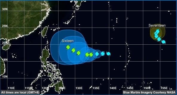
Tropical storm tracks taken on 01.09.10

 Tropical storm tracks taken on 02.09.10
Tropical storm tracks taken on 17.09.10
 Tropical storm tracks taken on 18.09.10
 Tropical storm tracks taken on 19.09.10
Tropical storm tracks taken on 20.09.10
 Tropical storm tracks taken on 21.09.10
 Tropical storm tracks taken on 22.09.10
 Tropical storm tracks taken on 23.09.10

Tropical storm tracks taken on 13.10.10
 Tropical storm tracks taken on 14.10.10
 Tropical storm tracks taken on 15.10.10
 Tropical storm tracks taken on 16.10.10
 Tropical storm tracks taken on 17.10.10
 Tropical storm tracks taken on 18.10.10 (landfall)
 Tropical storm tracks taken on 18.10.10 (after landfall)
 Tropical storm tracks taken on 19.10.10
 Tropical storm tracks taken on 20.10.10
 Tropical storm tracks taken on 21.10.10


 Tropical storm tracks taken on 22.10.10


 Tropical storm tracks taken on 23.10.10
 Tropical storm tracks taken on 25.10.10
 Tropical storm tracks taken on 26.10.10
 Tropical storm tracks taken on 27.10.10 (to be updated later)

 The Sumatra earthquake struck at a magnitude of 7.7M on 25th October 2010 at 21:42 local time (22:42 Malaysian time) off the western coast of Sumatra, Indonesia. The earthquake occurred on the same fault that produced the 2004 Indian Ocean earthquake. It was widely felt across the provinces of Bengkulu and West Sumatra and resulted in a tsunami that struck the Mentawai Islands.